Sunday, February 15, 2015

Tidbits, trivia

In varying degrees, the people who came to Indiana during the early years had an impact on the development of Fairfield, though it's not a classic that-makes-sense logic.

In truth, Fairfield's location limited its growth and certainly its ethnic and social diversity. The explanations are more clear with a cursory study of what was going on, where and by whom.

In the early 1800s, settlement was driven by an influx of white Protestants who were eager to (a.) find new futures and (b.) remove themselves from the economics of Southern slavery.

The economy that followed was agrarian. Timber, livestock, trade with the native Indians. Those first settlers were building dreams, not industry.

As Indiana matured and its population soared, so did its needs. Slowly, county seats were formed, towns established, roads cut from the forest and commerce expanded. By the 1830s, Indiana was ready to take its place.

Again, how this impacted Fairfield is simply a matter of connecting dots ... because the reality was that it did NOT affect Fairfield, unless you conjure up some what-if's.

Fairfield wasn't close enough to the middle of the action to actively profit from it and, by nature of that, did NOT profit from it.

Two major groups of people moved into the Whitewater Valley during the 1830s, both of whom essentially set up shop elsewhere for completely different reasons.

One group, the Quakers, came to Indiana to bolster the abolitionist movement that had sprung up in the decades prior to the Civil War. They came west on what was to be known as the National Road (U.S. 40) that came through ... Richmond, Wayne County.

The National Road (Cumberland Road) was actually begun in 1811, the same year that Franklin County was formed. Originally, it was simply a route to the Ohio River from the Potomac. Later, in the 1830s, it was rebuilt and headed west.

Among other components of this rather large movement of settlers was a standard Friends philosophy against hedging on their principles. Indiana Yearly Meeting of Orthodox Friends in 1837, "cautioned against joining with others not of our society, lest the standing of Friends as a peculiar people, separate from the world, be compromised."

In other words, don't hang around with people from Fairfield, who are not Quakers.

The other more significant group who came to the Whitewater Valley in the 1830s were Germans, both Catholic and Lutheran. Mostly, they had been lured to America because economics in Europe had largely been shifted toward a factory culture. Farmers and small shop owners were finding it impossible to thrive.

Religious sects migrated, especially the Old Lutherans of northern Germany, to avoid being united with the Reformed churches. Still others fled because they were political refugees. The latter were usually university-trained men with a zeal for liberty and democracy. The Germans regarded the West as a land of opportunity.

They came to America, armed with dedication and spirit, and found work building the Whitewater Canal, the "stream of dreams." They settled in Franklin County, in Highland and Ray townships, depending on their faith.

Fairfield's problem was that it wasn't close enough to the work or the road to the work.

Some other interesting tidbits about the migration of the 1830s:

* Since the roads were better, the weather more favorable, and the food more plentiful in the autumn, farmers were urged to move with their teams and wagons at this season.

* According to the Indiana Gazetteer or Topographical Dictionary of 1833, Brookville had 600 people, two gristmills, a sawmill, a cotton factory, a carding machine, five stores, three taverns, four lawyers, three doctors and a "large number" of artisans. (Only three taverns?)

* Fayette County established two new towns during the 1830s, Columbia and Berlin. (Neither is to be confused with Metropolis.)

* In 1838 Connersville's population was around 500 with "seven mercantile stores, one drug store, four taverns, four lawyers, four physicians, and two printing offices, besides mechanics of all kinds." (Only four lawyers?)

* Union County incorporated its county seat, Liberty with a population of around 500, and laid out one other town, Philomath, during the 1830s.  (Philomath? Yes, Philomath.)

* In Wayne County, Hagerstown and Cambridge City were laid out and both were on the canal route. Richmond platted earlier was growing by leaps and bounds. In 1832 it had a population of 1,252, and the next year it reportedly boasted an increase of 488. (They were actually lying about that, research concludes.)

* In 1822-23 delegates from Randolph, Wayne, Union, Franklin, Fayette and Dearborn counties met at Harrison, Ohio, to consider building a canal. The leader of this group was Augustus Jocelyn, a minister, and publisher of the Western Agriculturalist at Brookville. Jocelyn utilized his paper to create an interest in behalf of internal improvements within the valley. (By the way, the little drainage ditch that remains is far inferior to the overall scope of the actual canal.)


Sources: Indiana Magazine for History
Map is of the route for the original National Road. More on that: http://en.wikipedia.org/wiki/National_Road


Thursday, February 12, 2015

The Redbud

The iconic Fairfield Redbud was always "just there" on the roadside a half-mile or so north of town. It had a white rail fence around it and a wooden sign that simply said:

FAIRFIELD
REDBUD

No plaque, no details.

So what was the big deal?

For many who passed the tree on old SR101, probably no big deal at all. For the rest of us, ah ... not much of a big deal either.

"It's the oldest redbud in the state," my mother once told me.

"How do they know?" I probably asked.

"It just is," was probably the answer.

According to what we know, which is way more than enough to posit a true story about the old tree, it indeed WAS the oldest in Indiana, alleging all redbuds in the state had been observed and analyzed.

The history of the tree goes back to the Depression years when the Roosevelt administration opened the WPA jobs program, one that was responsible for generating the funds to build the state highway. Men worked on the WPA for a couple of days a week, depending on need. The pay was about a dollar a day.

You'll never get rich diggin' a ditch.

The highway replaced a road along the east side of the Whitewater River that nobody can seem to remember. Well, no wonder. This was in the early 1930s. Besides, the main route into Fairfield from Brookville was on the west side of the river.

In any case, when the state surveyed the route for the highway, other biologist-type people were called in to study the flora, the fauna, the trees, the streams ... and somebody stumbled across the old redbud tree. All this information comes from a man named Gayther Plummer, who knew much about the history of the tree.

The biologists were trained in such matters and were aware that the tree was much older than normal. Exactly how they determined this is a classified secret. I bet they counted wrinkles.

The highway was scheduled to be built not far from the tree but the path was modified slightly to allow the road to be close enough to the tree so that the public could enjoy it.

And so we did. The tree lived until at least 1974. It's gone now and so is any evidence it existed, including the fence. One wonders what happened to the tree but it was old and had suffered from some damage, probably a lot more as the reservoir was being built.

You can still drive along the old highway toward Hanna's Creek launch. At about the Union-Franklin county line, on the west side, the tree's ghost will linger.

A 1948 U.S. Geological Study map is attached. The circled area is generally where the tree was located. The red line indicates the course of  SR101, which bypassed Fairfield. We never could catch a break.

The photo at the top is a 1945 watercolor by a regionally esteemed Connersville artist named Fritz Conwell, whose work is available if you do an internet search for him.


-- John

Wednesday, February 11, 2015

Reference points

Two maps here for a frame of reference when visiting the lake area.


This is the area that became "New Fairfield" in 1974. 


The Dunlapsville-Roseburg area in Union County. The red line on the right on both maps is SR101.


Maps are from the U.S. Geological Survey.


Tuesday, February 10, 2015

Where's our courthouse?

There are several references to the ill-fated courthouse for Fairfield, all of which suggest the town got cheated because of some political shenanigans. It makes for a good story.

It's probably less accurate than entertaining.

In 1811, when Franklin County was created out of Dearborn and Clark counties, Fairfield enjoyed a location essentially in the center of the county, one that would normally be considered ideal for a county seat.


Four years after the county was created, Fairfield was platted, and a town square was set up with the apparent intentions of building a courthouse.

Trouble was, Brookville had already been established as the county seat and that wasn't likely to change. The thinking was, evidently, that the new town of Fairfield would be able to lure the courthouse away from Brookville. That was the story that came down over the years.

August Reifel, in his 1915 history, suggests there was little evidence Brookville was going to yield its clout and that there was almost no organized attempt to address it.

What changed for Fairfield was that in about 1819, Jonathan McCarty, one of a long line of illustrious McCartys in the Whitewater Valley, was prominent in helping create Fayette County, whereupon he immediately became a principal political leader in Connersville.

A year or so later, Union County was created for reasons that are more vague, though the standard story is that residents there wanted their own government. They set up a courthouse in Brownsville initially and moved it to Liberty during a bit of a range war.

A range war that did not happen in Franklin County.

By the time the lines were drawn, Fairfield was on the northern edge of Franklin County, and had its town square and a beleaguered notion that it could someday be a town of prominence.

It never happened. 

An 1882 Atlas describes the events that allegedly occurred.

Fairfield was once a rival for county-seat honors in Franklin-Union counties. Before the division of the counties, Hon. Mr. McCarthy was elected as representative to the Legislature, and during his term of office the matter of creating a new county came up and, and finding that the bill was to pass, making what is now known as Franklin county, saw more money for himself in aiding Brookville to secure the county seat. 

He had friends purchase a large amount of lands in and near Brookville, and thus what had been planned from the early date, namely, to make Fairfield the seat of justice, fell through and Brookville was awarded the honors, so state the citizens of Fairfield. Before the division of the county, Fairfield was nearer the center of the territory than was Brookville.

When Fairfield was laid out, the proprietors donated a public square in the center of the plat, and this is still used for such, minus the coveted court house which it was intended should at no distant day be erected theron. Some good hitching posts and a town pump are all that now mark the "Square" as being public property.

There's little doubt McCarty was a shrewd businessman and an opportunist.

The hitching posts disappeared soon after the 20th century came around. The square itself served no particular purpose though, for a time, a large screen was set up to allow the public to watch free movies. That practice ended in the middle 1950s.

The so-called Eads addition, which was added in 1817, also included a "public square" that adds more fuel to the story. William H. Eads was, along with McCarty, a powerful political figure of the time and both were part of the first Indiana General Assembly. It is possible that Eads saw Fairfield as a center of county government. Could be, he had his own plan. Could be, McCarty beat him to the punch.

The Eads addition eventually was used for the township school. 

-- John

Photo: From 1961, Merle Updike (my grandfather) in front of the Fairfield town square. In the background, remnants of what was the Loper buggy business.


Monday, February 9, 2015

Early settlement, commerce

Who lived in the Whitewater Valley in those early days -- the ones right after America became the United States?

Indians mostly, since they effectively "owned" the land until the battle at Fallen Timbers, Ohio. At that 1794 battle, Gen. Anthony Wayne forced concessions that led to the Treaty of Greenville in 1795.

That treaty line established the western border of what was to become Fairfield Township.

Other additional tracts of land were purchased from the tribes, mostly the Miami, to eventually create what we recognized as Franklin County. The county was basically carved out of Clark and Dearborn counties in 1811. Details, details.

Chelsea Lawlis, who did most of the research on the history of the Whitewater Valley, explored some of the details of the demographics in a 1947 article in the Indiana Magazine of History.

While the land was not offered for sale until 1801 at Cincinnati, squatters had already entered the territory in large numbers. In a letter written from Cincinnati, January 8, 1798, Winthrop Sargent told Timothy Pickering, Secretary of State, of the great increase in the number of intruders upon United States lands. According to Sargent, there were nearly two hundred families just over the Great Miami. Many of them had fled to that place to escape from their creditors. Sargent indicated that these settlers were cutting and wasting timber.

The native Indians were not quick to leave, apparently.

Settlers complained of having their horses stolen by the Indians since the beginning of the recent Indian war. Many had been disappointed in getting land in Kentucky. The settlers asked permission to purchase the land on which they had settled, in quarter sections if possible.

The early pioneers learned the hard way -- the Whitewater Valley still belonged to the Indians. The Greenville treaty had officially solved the Indian "problem" but it took patience and commerce to effectively settle the dispute. Not every native was inclined to follow an imaginary line that meant nothing to them.

Greenville did, however, restrict white settlement west of the line. Those squatters were less inclined to be protected by the few government soldiers in the area.

True commerce came to the valley in 1803 when entrepreneur John Conner opened a trading post not far from what was to become Cedar Grove. In 1808, Conner put up a building a few miles north of that and named it Connersville. In 1813, Connersville was given "town" status.

The valley began to fill up after that with immigrants from South Carolina who founded the Carolina Settlement; numerous Kentuckians; and many Quakers from North Carolina and Pennsylvania.

Although most of the settlers came from the South, they were largely from the nonslaveholding class and many left that region in order to reject slavery. White protestants, almost exclusively.

Lawlis adds:

An indication of the rapid growth of the Whitewater Valley can be gained from an examination of the number of towns plotted during this decade. Brookville had been laid out in 1808. Fairfield was plotted in 1815, Union (Whitcomb) in 1816, and New Trenton also in 1816. Further up the valley in what is now Union County, the new towns formed were Brownsville in 1815 and Dunlapsville in 1817. Wayne County gave birth to Centerville, 1814; Jacksonburgh, 1815; Richmond, 1816; Abington, 1817; and Newport, 1818.

Brookville attained significant prosperity in the years immediately following statehood in 1816 because of its location near the Whitewater River. Flatboats served its economy. It grew from a dozen houses to "upwards of 80" by 1817, according to Samuel R. Brown, in The Western Gazetteer.

A sharp decline followed in 1818 due to new federal restrictions on loans, on which the pioneer economy depended heavily. The staggering boom would soon end as agricultural prices dropped sharply. The migration continued but at a much slower pace. It was becoming more difficult to buy land on credit.

A study of the age groups listed in the 1820 census indicates that it was still chiefly the young people who were migrating.

1820 Census data, by age group

41 percent, under 10
56 percent, under 16
73 percent, under 26
92 percent, under 45

Population in 1820

Fayette County, population 5,950, 9 blacks.
Franklin County, population 10,763, 65 free blacks.
Wayne County, population 12,119, 66 blacks.


Sunday, February 8, 2015

Bridges

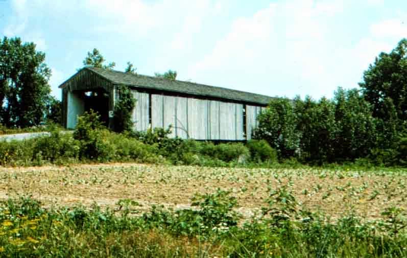
Fairfield's iconic covered bridge celebrated a glorious history and a brutal demise.

The structure was 300 feet long, 15.5 feet wide and represented one of the longest structures of its kind in Indiana when it was built. When the end came, it was gutted, and burned by vandals. That was in 1973 -- just over a century after it was built by J.L. Kennedy.

The bridge withstood the ravages that wrought havoc farther downstream during historic floods in 1913, 1937 and 1959.

The Fairfield bridge was one of several across the East Fork. A shorter bridge across the stream at Dunlapsville was also burned in 1971 by vandals. Its replacement currently crosses the river a few hundred feet south of the original site.

Another bridge at Brownsville was dismantled in the middle 1960s and stored in Indianapolis until 1987 when the city of Columbus bought it and installed it in Mill Race Park, where it remains a Bartholomew County tourist attraction. That bridge has no relevant connection to the construction of Brookville Reservoir, since the town was never threatened by the lake.

Other farm bridges along the East Fork came and went over the years. At least one is marked on an 1882 Atlas south of Fairfield at Templeton's Creek. Many bridges across the East Fork were destroyed by floodwaters, and replaced by steel structures. Few of their replacements remain.

Indiana has a fairly large number of useful covered bridges, including two in Franklin County (Enochsburg and Rockdale) and lots of them in Parke County.

As well, a covered bridge over Indian Creek on the Indiana-Ohio line east of Bath was in use until 1966 when it was dismantled and moved to Bebb Park in Butler County. That structure was about 150 feet long and was built around 1886, according to Hamilton, Ohio, historian Jim Blount.


These photos may prove useful.


Dunlapsville bridge, from the east entrance


Fairfield bridge, prior to 1913. Note the smaller bridge that went across a mill race


The red marker shows the general location of the Fairfield bridge. Causeway Road bridge crosses the lake at Fairfield Marina.


Covered bridges at Enochsburg (above) and Rockdale (Snow Hill).


The pristine Brownsville bridge at a Columbus Mill Race Park


Bath-Oxford bridge, removed in 1966 to Morgan Township in Butler Co., Ohio.


By way of scope, the Fairfield bridge was much longer than any of these.

Photos are from various sources, including countyhistory.com, bridgehunter.com (thanks Jan) and Columbus tourism websites.


Friday, February 6, 2015

Origins of Fairfield

This topic will be ongoing since the main thrust of the blog is to acknowledge the town's 200th anniversary.

To get a sense of that, consider that between 1810 and 1820, the population of Indiana (territory and state) grew by 500 percent -- from 24,000 to about 147,000. As more settlers arrived, more came with them. They got married, had babies and lived long enough to see Butler almost win the NCAA tournament twice.

Purdue, not quite so often.

Historian August Reifel, in his 1915 tome, reports that "There is no way of knowing how many people lived in Franklin County when it was organized on Feb. 1, 1811. It is fair to presume that there were at least 5,000 people in the county."

Indiana, not yet a state. 

Fairfield, not yet a town.

Other anecdotal stories connect to all that, the most famous legend being of the eventual location of the county seat. That will be explored in some detail later on but Reifel and others insist the story is more interesting than the fact.

In any event, the research goes as follows: Fairfield was platted October, 1815, by Hugh Abernathy, George Johnston, Tomas Osborn and James Wilson, the four corners of their respective lands being in the center of the platting. An addition was made in 1817. It is situated in section 21, township 10 north and range 2 west.

So ... why?

For the obvious reasons, is why. These men saw their numbers growing. More and more settlers had moved into the valley. There were crops, and a need for services. A saw mill, a millstone, a blacksmith, a church, a school, a cemetery. As well, impending statehood (1816) was not lost on them. Being a "town" inside a "state" probably mattered, even if they couldn't prove it. 

The way you get that stuff is to set up a place where it can exist. These four settlers were able to set aside land in what they considered a prime location. There, they built a town square where a seat of government could exist. Licenses, tax collections, weddings, lottery drawings. ...

All four of these men show up on various maps throughout the first half of the 19th century. Until 1817, most of that would be centered in either Bath or Brookville townships, depending on your search criteria. Fairfield Township was not established until around 1821, as a result of it having a town and a central method of governing itself. The township was carved out of Bath Township.

For a time, Fairfield provided all the necessities of any pioneer community. As numbers continued to grow, the needs of the Whitewater Valley changed and were modified. The town of Fairfield found itself less useful as a center of commerce. 

But it was still home.

And it was home all the way up to the end.

-- John

Photo was provided by county historian Don Dunaway, and it's from a 1914 book by legendary photographer Ben Winans. Location: Approximately where the Causeway Road turns onto the road leading to Fairfield Marina. (Updike Road in case you care.)