Showing posts sorted by relevance for query greensboro. Sort by date Show all posts

Wednesday, March 4, 2015

Blooming (Greensboro) Grove

We'd be derelict if we ignore the surrounding communities in relation to the history of Fairfield Township, only because ... well, they exist. Almost all of them still do, which suggests they have a history they haven't readily identified.

Perhaps it isn't history at all, just the passage of time.

To the north, Harmony Township, to the east, Bath Township, and to the south, Brookville. To the west, Greensboro.

Er ... Green Brier.

Er ... Blooming Grove.

Big doin's? Well, actually not until around the middle of 1812, which isn't Blooming Grove's fault. It's that there wasn't much need for it until then. And until 1809, it wasn't legal anyhow. Complicated? Hardly, but it's worth a go.

Blooming Grove Township was founded in May 1817, and parts of it were once located in what is now Jackson Township in Fayette County, the area generally surrounded by the little town of Everton on State Route 1.
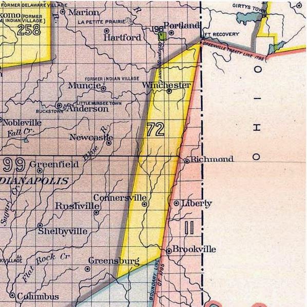
The township was carved out of a section of land known as the Twelve Mile Purchase, which territorial Gov. William Henry Harrison negotiated with the native Indians. That was in 1809 and the accompanying map shows where it was located. The area is just west of the Greenville Treaty Line.

Greenville Treaty was, at the time of Fairfield's founding in 1815, the western border of "white country." The Twelve Mile Purchase shoved the line westward to where the Fayette County town of Orange is located.

Settlement in that area was slow at first until something resembling a road developed between the economically prosperous settlements of Brookville and Connersville. The spot almost smack-dab in the middle was where the little village of Greensboro was born. Probably not much more than a trading post, with the route to the east toward where Fairfield was growing and to the west (Posey Township) where the productive West Fork of the Whitewater took traders downstream.

To that end, as 1809 turned into 1812, the road got busier and the need for a stopping point somewhere between Brookville and Connersville seemed useful. Connersville was given town status in 1813 after being founded in 1808. Brookville was founded in 1808.

The 1882 Atlas of Franklin County says the first settlers in Blooming Grove Township were Jacob Blacklidge and Ralph Williams, who set up in 1811 near Duck Creek in the southwestern portion of the township.

The land was slowly bought up and the community was born along the "highway."

John Naylor and James Sherwood hired a surveyor named Joseph Allen to lay out the town in July 1816. They added a section the following winter and named their little hamlet Greensboro, which was the name of the town in Maryland from where they had emigrated.

Greensboro, it was.

The Atlas goes on to explain how it became something else before it became what it is. "The name ... was often perverted to Green 'Brier' by those who were interested in other towns than this one. Mr. Henry C. Hervey says, in a recent letter:

"The writer came to the town on the 1st day of September 1834 to being a six years' apprenticeship at a trade, which term he fully and faithfully served, and from that date to the present time has witnessed the growth and changes that have occurred. The oft-repeated statement about the original name of our village being Greenbrier is incorrect. The name was Greensboro."

So what went wrong?

When Greensboro applied to get a post office in the 1830s, the town was told that there was already a place by that name in Indiana. So they decided, since the township was Blooming Grove, so would be the name of the village. After that, the state legislature agreed that the town could change its name from Greensboro to Blooming Grove.

Many of the first settlers came in the period of 1816-1819.

The Atlas adds some interesting trivia:

* James Hughell was the first white child born in the township.
* James Webb had the first blacksmith shop.
* The first schoolhouse was built in 1817 in an area owned by James Harvey, whose property also contained the first graveyard, just east of town.
* William Richardson built an early mill on Duck Creek.

Blooming Grove's social community in the early days and into the 1880s was driven by its churches, with the Methodist Episcopal Church being the leader. The Atlas describes the church. "The society has a large and commodious house of worship in the village, which building was erected in 1869. A little distance north of the village is a cemetery, where many of the early workers of Blooming Grove are buried."

Joseph Williams was an early preacher, perhaps the first. The first church was known as Duck Chapel.

How the town relates to Fairfield is general in nature. Those who wanted to trade with Connersville and Brookville would have moved their goods across the river at various points. The covered bridge later on would have simplified that. Blooming Grove's location was perfect for that. As a commercial center began to develop west of the village, it became somewhat of a crossroads.

As times changed with the introduction of the Whitewater Canal, Blooming Grove's value diminished.

But you can still go there.

-- John

Sources: Ken LaMont posted the historical photos on Facebook. I've shamelessly appropriated them to illustrate this blog entry. Other information comes from generally available historical resources.


This school eventually became a community center.


An 1882 plat map of the town.


The road down the hill, east to Fairfield, 1947.


And you can get to New Fairfield from there.


Many names of the original settlers show up on on this 1882 map. Sherwood, Harvey, Naylor, Wagoner, Erb. Also note where the "mounds" are located. Those were archaeological sites of the ancient Mounds tribes who populated the Whitewater Valley literally thousands of years ago. (You may want to save the map to your computer to get a larger view of it.)



Wednesday, July 15, 2015

Franklin County town trivia

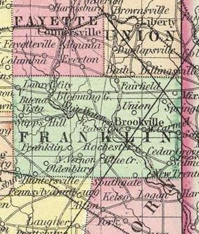
1856 map shows towns that might not exist today.
Vas you effer in Philanthropy?

How about Sentinel?

If you have been to Philanthropy, you probably passed through Sentinel to get there.

Or so asserts August Reifel in his 1915 history of Franklin County.

Those two towns exist today but you won't know them by those names.

As you might not in several other communities in Franklin County, some of which were never platted in the first place despite good intentions.

Lucky for us, we only have one name for Fairfield and we know right where it ... was.

Reifel's history cites nearly 40 planned communities in the area south from Connersville to Dearborn County that either never truly existed or lasted only until the families who lived there decided to do something else with their free time.

Most likely, you've heard of Old Bath, which is really Coulter's Corner, two miles west of Regular Bath. Blooming Grove was originally known as Greensboro, alternatively as Greenbrier. (At one time, there was another "Bath" just north of Fairfield, which eventually just became Bath Springs.)

Some other interesting towns:

Cedar Grove was once known as Rochester, and Whitcomb was originally platted as Union.

Blue Creek eventually became Klemme's Corner and Duck Creek Crossing evolved into Metamora.

Sprinkle in some places that are generally known but hardly towns -- Sharptown, Highland Center, Yung, Rockdale ...and if you've been to Palestine, you've been to Wynn. Same place.

At one time, the area including Connersville was in Franklin County so a few platted towns that didn't develop are located in Fayette County, including Darlington, New Washington, West Union.

Ferona, Franklin, St. Bernard, Lebanon and Sabina never took root in Franklin County, though many of these non-towns were victims of the name game. They could plat all they wanted, but there was not going to be two towns in Indiana named "Lebanon."

Not having a post office or a way to get there was often a deal-breaker.

No one seems to know why such towns were promised, never platted, or why anybody even bothered in the first place.

Union County has similar dots on the map, such as Scratch Gravel, Salem, Philomath, Contreras, Charlottesville.

Google can pinpoint most of them, oddly.

Reifel says Franklin was close to being a town and there is evidence that freed slaves were being given a chance to move there, a plan that never really amounted to much. It's in Butler Township.

St. Bernard boasted a sawmill.

There was also apparently a North Vernon in Franklin County. What it became is uncertain.

We are also sad to hear that Ceylon never amounted to much, after Thomas Anderson bought the place and renamed it Andersonville.

Other chunks of farmland became part of Brookville over the years, such as Buncombe and Butler's Run, or Stavetown.

And somebody evidently decided "Kokomo" was a good name for a Franklin County town. We'll have no luck finding it.

That brings us to Sentinel (Mt. Carmel) and Philanthropy (Scipio.)

Happy motoring.

By the way, do you know the directions to Baltimore?

YES, BALTIMORE

Reifel goes into some detail about the planned community of Baltimore that was designed to profit from the immense economy of the lucrative Whitewater Canal. Reifel calls it a "paper town ... it never passed beyond the plat stage and the subsequent flamboyant description of the proposed town in the papers when its lots were opened for sale."

Evidently the developer propped up something pretty amazing in trying to sell Baltimore to investors along the canal.

"Probably no town in the county was ever pictured in more glowing terms than that laid out by James Conwell in 1836."

Conwell advertised in the newspapers that he had available for sale about 300 lots, situated on the Whitewater River.

Conwell's plea was succinct. "For many years past, the subscriber (Conwell) has been urgently solicited to lay off a town at this point, and dispose of lots; but has always heretofore refused on the ground of his irreconcilable aversion to trifling country villages, whose population is too frequently composed of the idle, dissolute and intemperate portions of the community."

In other words, Conwell was determined to build an upper-class town that had substance, growth potential and did not include drunken bums or sinners.

Indiana's internal improvements program was in full gear, and the seemingly endless supply of wealth to be had from the canal gave Conwell added ammunition.

His sales pitch was loaded with superlatives, citing "natural advantages it possesses, others that will render it a point of great importance for business of every kind, and secure the erection of a town not surpassed by many."

Conwell's mills did, for a time, generate considerable business in carding and fulling wool, a tannery and a lucrative blacksmithing business, as well as grain and saw mills.

The pitch went on to say that "during the last 16 years that the subscriber has resided in this neighborhood ... but a single death has occurred during that time."

Conwell hoped to build Baltimore as the canal system grew. Conwell apparently believed his industrial park would endure and grow and with it, his dream town of Baltimore. He acknowledged that there was talk of a railroad but dismissed it in his appeal to land speculators. "The White Water canal will be the obvious channel through which this immense trade will pass."

If you were interested, sobriety and good moral character were necessary. No gin mills were in the plan, but seminaries would be welcome.

A third of the purchase price was necessary immediately.

Conwell eventually just called the place "Laurel."


Friday, June 12, 2015

Kanawha Trace

If you type the words "Kanawha Trace" into your search bar, you may come up with a series of links to some long-distance running clubs. Apparently the race in the hills of West Virginia is universally popular.

Around 215 years ago, nobody was in a rush. But the Kanawha Trace was busy enough.

It was a link that allowed Quakers and Dunkers to travel westward from Virginia across southern Ohio and, in some cases, to the Whitewater Valley.

It began in north central North Carolina, according to an essay on Ancestry.com, where the Moravian Brethren, Friends (or Quakers) and German Baptist Brethren (Dunkers, Church of the Brethren) had major settlements.

In fact, the origin was at a place called New Garden Friends Church in Greensboro. (It doesn't say which side of the building, however!)

At the trail's end, in Fountain City (once called Newport, Ind.) , a church with an identical name was eventually established. It's still there.

Before that, pioneers crossed Virginia toward the Ohio River, following a Shawnee path near the New (aka Kanawha) River. In those years, West Virginia was still a part of Virginia.

At a point where the New flowed into the Ohio at Gallipolis, the settlers crossed into Ohio.

The Ancestry.com document, written in 1998 by Merle C. Rummel, is based on information recorded by Argus Ogborn, a Quaker historian in Richmond. It is quite detailed in following the Kanawha Trace westward across Ohio.

What makes Kanawha interesting is that it isn't well known to students of the westward migration.

Roads going north through the Shenandoah Valley and into Pennsylvania and then west to Ohio or west into Kentucky through the Cumberland Gap and then north to Ohio were well known, but very much out of the way for the area of southwestern Virginia.

This appears to be a segment of society that just loved to migrate. Many of them were first- or second-generation immigrants from Europe, particularly Germany. They'd settled in Pennsylvania first, then moved downward into the Shenandoah Valley and Blue Ridge areas of Virginia.

By the middle of the 18th century, they had their eye on the land west of the Appalachian Mountains, which formed a barrier to easy travel, and Indian hostility prevented settlement in that direction. Later, British rule made settlement west of the mountains illegal.

After that, the Americans declared their independence.

By 1800, the Quakers were itchy to move again. So they followed the New River (which is actually very old) across what became West Virginia ... and a few of them ended up in the Whitewater Valley.

The trace was used until around 1812. It largely follows alongside the course of the New River to Gallia County, Ohio, and cuts through such places as Rio Grande and Chillicothe on its way across to Indiana.

A compelling 1981 novel "Follow the River," by Alexander Thom, explores this area in an historical adaptation of two women who must traverse the valley to escape their Indian captors.

THE DUNKERS
The German Baptist Brethren apparently did not endeavor to settle in the Whitewater Valley but farther south in Clark, Washington and Lawrence counties. A 1980 research document in the Indiana Magazine of History explores their history in some detail.

"As was the case with many religious groups, Brethren were quick to move west with the frontier following the American Revolution. Dunker families had crossed the Allegheny Mountains into Kentucky shortly before 1790. Ohio had organized congregations by 1802, Indiana by 1809, and Illinois by 1815."

Many of their congregations disappeared during the 1820s during what was known as a "Restoration" of primitive Christian principles. That eventually evolved into the Disciples of Christ movement.

The German Baptists are probably more closely aligned to the Mennonite Church.

The Brethren were distinguished from other religious groups by several important characteristics, perhaps the most significant of which was their form of baptism. The Brethren insisted on trine (i.e., thrice repeated) immersion, with face forward, in flowing water.

NEW RIVER (Wikipedia) 

MORE ON THE DUNKERS