Showing posts sorted by relevance for query bridge. Sort by date Show all posts

Sunday, February 8, 2015

Bridges

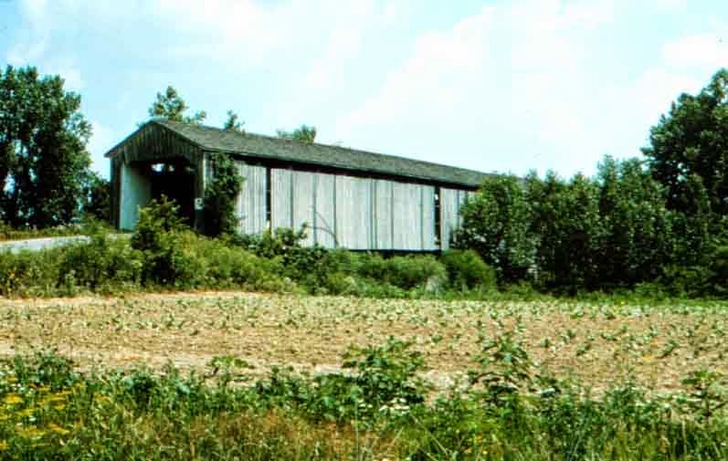
Fairfield's iconic covered bridge celebrated a glorious history and a brutal demise.

The structure was 300 feet long, 15.5 feet wide and represented one of the longest structures of its kind in Indiana when it was built. When the end came, it was gutted, and burned by vandals. That was in 1973 -- just over a century after it was built by J.L. Kennedy.

The bridge withstood the ravages that wrought havoc farther downstream during historic floods in 1913, 1937 and 1959.

The Fairfield bridge was one of several across the East Fork. A shorter bridge across the stream at Dunlapsville was also burned in 1971 by vandals. Its replacement currently crosses the river a few hundred feet south of the original site.

Another bridge at Brownsville was dismantled in the middle 1960s and stored in Indianapolis until 1987 when the city of Columbus bought it and installed it in Mill Race Park, where it remains a Bartholomew County tourist attraction. That bridge has no relevant connection to the construction of Brookville Reservoir, since the town was never threatened by the lake.

Other farm bridges along the East Fork came and went over the years. At least one is marked on an 1882 Atlas south of Fairfield at Templeton's Creek. Many bridges across the East Fork were destroyed by floodwaters, and replaced by steel structures. Few of their replacements remain.

Indiana has a fairly large number of useful covered bridges, including two in Franklin County (Enochsburg and Rockdale) and lots of them in Parke County.

As well, a covered bridge over Indian Creek on the Indiana-Ohio line east of Bath was in use until 1966 when it was dismantled and moved to Bebb Park in Butler County. That structure was about 150 feet long and was built around 1886, according to Hamilton, Ohio, historian Jim Blount.


These photos may prove useful.


Dunlapsville bridge, from the east entrance


Fairfield bridge, prior to 1913. Note the smaller bridge that went across a mill race


The red marker shows the general location of the Fairfield bridge. Causeway Road bridge crosses the lake at Fairfield Marina.


Covered bridges at Enochsburg (above) and Rockdale (Snow Hill).


The pristine Brownsville bridge at a Columbus Mill Race Park


Bath-Oxford bridge, removed in 1966 to Morgan Township in Butler Co., Ohio.


By way of scope, the Fairfield bridge was much longer than any of these.

Photos are from various sources, including countyhistory.com, bridgehunter.com (thanks Jan) and Columbus tourism websites.


Sunday, March 1, 2015

More about roads

By 1807, the need for improved roads was significant in the Whitewater Valley.

The original paths that had followed the old Indian trails had worked in helping settlers find their land, but they didn't exactly connect to the places where they were needed. The main reason was that communities often sprung up as the result of someone taking a DIFFERENT Indian path and ending up in a slightly more advantageous place.

Location, location, location.

The county courts were essentially in charge of mandating road construction and levying the means to pay for it. A law in 1807 required all able-bodied men to work several days a year to help build roads.

The result was that newer roads were to include mileposts. Presumably the zero point was the county courthouse.

The width of an established road was usually 30 feet, up to 66 feet in places.

The law also mandated that, at the fork of each highway, the road supervisor was required to erect and keep a signpost "directing the way and mentioning the most remarkable places on each road."

Ten dollars was forfeit to the supervisor, for the use of the roads, from any one defacing or altering this inscription so as to destroy its utility.

Then came the topic of tolls. The 1807 act and an updated act in 1818, provided for private "cartways."

These might be closed by means of gates, but the public was to be allowed to use them. They were to be not over 18 feet in width and maintained by those petitioning for their establishment.

Roads were financed in part by a land tax, which affected farmers to a large degree. In some cases, these farmers chose to work on the roads in exchange for payment of the land tax. The 1818 law allowed for that. That usually amounted to about 75 cents a day.

Bridges were often financed by toll gates.

An act of the Legislature, approved Jan. 1, 1819, authorized John Barricklow and Gideon Cummings to build a toll bridge over Laughery Creek, in Dearborn County, at the town of Hanover. The statute required it to be at least 16 feet wide in the clear, with a good railing on the sides, "for whatever might pass that way"; it was not to be allowed to obstruct the navigation of the creek; the mail and troops were to pass the bridge free; the commissioners of the county were to fix the rates of toll; these rates were to be posted on the bridge in large print, in the English language; after 30 years the county might buy the bridge at a price fixed by five men — two chosen by the county, two by the owners of the bridge, and a fifth chosen by these four; the county was not to open another bridge nor a ferry within a mile of this bridge while it was kept in repair as a toll bridge.

Nearly all larger bridges in those early days were built of wood, with stone pillars rather common.

The Indiana History magazine describes the process for bridging smaller streams:

"Small streams were bridged by throwing trunks of trees across the stream for "sleepers," then on these a floor of heavy poles or of logs split in halves was laid. The smaller bridges were not roofed, but larger ones frequently, if not usually, were. This protected the wooden pins from decay — for the timbers were mortised and pinned together; iron bolts for such purposes were not yet in use."

One would assume that the East Fork of the Whitewater and its feeder creeks would have been relatively well-laced with temporary bridges, structures that probably only endured after the spring high water season. But such a bridge could be constructed easily with an abundant amount of available timber.

What vehicles traversed Indiana's roads in those days?

Carts were in use very early in Indiana and were used by farmers to haul wood to market and to bring grain in from the fields or to take it to the mill. Sleds were employed for the same purposes, more often in winter. A cart could be pulled by a single horse.

Wagons, while functional on the farm, were somewhat clumsy on the roads and were usually too heavy to maneuver. They were also unreliable and were prone to broken wheels or axles after extended use. Blacksmiths had plenty of work to do in supplying the demand for vehicles and tools.

Carriages were not plentiful. Some of the more well-to-do in the towns had them. Occasionally, too, some European traveler on a scientific tour or a trip to invest in western lands drove through in his chaise or carriage. A stagecoach into Indiana would have been an uncommon sight, though not rare.

I am still searching to learn what the tolls were on private roads and bridges. A toll gate existed on the south side of Fairfield as late as the 1880s.

As well, apparently the use of gravel for Indiana roads wasn't common until the 1850s, and there's no real good explanation for that though it would have been quite a bit of work. The best explanation was that the road builders just didn't know where the gravel pits were located, Once gravel arrived, Indiana was in the fast lane.

The illustration was gleaned from an internet search that yielded this information.

WILD HORSE BOOKS 


Wednesday, March 19, 2025

Your bad bridge story

 Lawrenceburg Press, July 14, 1870

THE FALL OF THE WHITE WATER BRIDGE

---

The long iron bridge over White Water River, about a quarter of a mile below Harrison, fell on Monday with a terrific crash, carrying with it Mr. Jerome Johnson, who was crushed to death.

Mrs. Johnson as hauling an enormous saw log of green sycamore about four feet in diameter, and was accompanied by four other men -- named Essex, Dow Pelton, Hatfield and Geo. Bartlet. Of these only Mr. Bartlet was injured and he not seriously.

When the bridge fell, Mr. Johnson who was walking alongside of his wagon, was thrown down and partly under the wagon, being entirely under water when taken out of the wreck. He lived only about 30 minutes. 

The bridge has for a long time been deemed unfit for travel and only a short time ago, some of the Commissioners by request of the citizens, visited and inspected it and pronounced it unsafe. They at the time and since until the accident of Monday that resulted so disastrously, neglected to put up any warning or close the bridge from public travel and -- we hope we have been falsely  informed -- one of the commissioners at the time of viewing the bridge, said that they would not spend any money upon it until after the election, as it would be used  against them as an electioneering hobby!

Certain it is, however, the bridge being unfit for travel, should have been closed against all vehicles and repaired. It has been a bad job from the beginning and the commissioners who received it from the contractors had no more brains nor honesty than the builders, or they would never have received so rickety a structure as the property of the county. 

The other two spans are racked until they are more than three feet out of a straight line and are liable to fall the first time the wind strikes it. 


NOTE: Try not to blame the guy who thought taking a 4-ton sycamore log across a rickety bridge was a good idea. 


Sunday, January 5, 2025

The flood of '52

 Here and there, we are reminded that over the centuries of human population in what we know as Indiana, there is occasional heavy rain. As the purpose of the Fairfield 200 blog is to acknowledge two of those centuries as our history, it’s worth noting that flooding caused our demise.

Flooding elsewhere. But in 1852, it’s doubtful anyone blamed the problem on Fairfield, although they suffered all the same. This dispatch published in an outpost paper in Aurora (Dearborn Co.) called the Independent Banner:

A deluge of rain!

“The heavy and continued rains of Wednesday and Thursday (Dec. 25-26, 1852) in the Valley of the two Miamis caused a sudden rise of water in those streams and their tributaries, which yesterday swept in a flood over their banks, carrying away fences, out-houses, dams, mills, lumber and in many places, bridges in its course.

“A larger portion of the Eaton Railway is submerged and several bridges carried away. The Venice bridge on the Brookville and Oxford Pike was so obstructed with floating drift as to prevent it being traveled through.

“The passenger train on the Hamilton Railway that left yesterday with a large number of passengers, passed the bridge beyond Hamilton when a messenger on horseback announced to the conductor that the flood had risen to such a height and bore with such force on the middle pier of the Twin Creek Bridge that it had burst it asunder, and that the adjacent embankment in many places had been washed away.”

In another column:

“At Connersville the river at that point was high and rising rapidly and the water had come so near the telegraph wire which extends over the river that it had to be taken down to prevent the driftwood from carrying it off.”

* * *

Near Fairfield, while the covered bridge was still 2 decades in the future, one assumes a bridge across the river existed, and it probably washed out. A mill on the river there was destroyed (see clip at right).

The Brookville American, on Jan. 7, 1853, published an article saying the Whitewater Canal had been damaged and would be repaired and in working order within a short time.

“The canal must and will be repaired. And it can be done in three months as well as nine. Then there will be six months for the mills and merchandise to be making money – and six months to collect toll. Repair quick and $40,000 in tolls will be saved to the canal and ten times as much to the business of the valley.”

The lot of damage occurred at Cambridge City. “The destruction of private property has been immense.” Serious damage also occurred at a feeder dam near Harrison.

A woolen factory and bridge were destroyed at Laurel, The paper said that “it was supposed in January 1847 that the destructive flood that occurred on the first day of that month was probably a centennial visitor.”

The problem was, people believed it and built their structures along the river assuming it couldn’t happen again. “The ruin and desolation cannot be particularized.”

The paper went on to speculate that farming methods of the time, the digging of drainage ditches, was messing with the ecology of the swamps near the rivers and that they could expect more flooding in the future, perhaps every year. It would be many years before they learned their lesson about tampering with the river.

In the same article, the paper said the Spear and Stevens paper and flouring mills would be repaired as soon as they had the money. The paper said the Spears mill had been damaged several times in the previous 5 years and invoked some patriotic zeal toward the challenge.

“Some Generals by an adroit maneuver, turn defeat into victory. Some men by commercial failure thereby learn to lay a sure foundation for future success and final wealth. In others, their real resources and true greatness are never developed until they are brought out by adverse fortunes.”

Amen.

I don’t know specifically where the Venice bridge was located, but it might have been the one at the state line east of Bath. That bridge was dismantled and rebuilt in Butler County.

LINK TO THAT HERE 


Sunday, March 22, 2015

Deadly streams -- Part 4 (Brookville's pain)

Thanks: Thomas Keesling collection
An ironic detail that can easily be overlooked in the face of the horrendous flood of 1913 is that the community this blog is intended to address actually was scarcely affected.

Fairfield, serenely perched on the East Fork of the Whitewater River, was never threatened by the incredible forces of the raging streams that burst out of their banks over much of the Midwest.

Downstream, in Brookville, the residents would fare far worse. In other sections of the country, the disaster was maddening and deadly. An estimated 650 died in the flooding, nearly 400 of them in Ohio. Central Indiana, including Indianapolis, also recorded significant loss of life. The numbers are not accurate enough to matter.

This entry deals with how Brookville was affected. Later on, some interesting anecdotes about the flood and why it ranks as one of the country's worst calamities. (The Johnstown, Pa., dam rupture and flood of 1889 took more than 2,200 lives.)

August Reifel's 1915 history, produced only two years after the flood, paints a scary scenario:

March 25, 1913

"Hundreds and thousands of dollars’ worth of property was destroyed and fifteen lives lost. Six hundred people in Brookville were rendered homeless and scores of dwellings swept away and torn to pieces. The flood was the result of many days’ rain, and every rivulet and creek in the valley was a roaring torrent, which went sweeping down the two branches of the Whitewater River.

"The heaviest blow was sustained at Brookville, where the two streams unite. Both valleys — that of the East fork and West fork — were submerged in many feet of water. At the depot and paper mills the water was fully 20 feet above the tracks.

"The earliest intimation of danger was soon after midnight on Monday and about two o’clock a.m. the scenes in Brookville were beyond description. The electric light plant was under water and all lights were put out, so that lanterns had to be brought into use by the hundreds of people who had been startled by the shrill steam whistles and the clanging of church bells.

"People in the flats were warned and as fast as possible conveyed to safe places, while their property was swept away and lost forever.

"When daylight came, the scene was one of desolation. The only land to be seen in all the valley part of town was a narrow strip from the Christian Church to the old bank building. Men and women were seen perched on housetops, waving distress signals from windows and clinging to wreckage.

"The water continued to rise until it reached its climax on Tuesday morning at nine o’clock, when it reached a point 10 feet higher than any previous flood record."

In Brookville, the rain continued. The heavy downpour dumped more water into the swollen rivers, sending it downstream to the bulging Miami, which couldn't take it. the water continued to rise.

"The greatest loss to property in the county was its bridges. The railroad bridges at Laurel and Brookville, the one over Salt Creek, the one over Duck Creek, at Metamora, the paper mill bridge at Brookville, and old Stringer Ford Bridge and the “Old White Bridge,” and the new concrete bridge. Also the bridge at New Trenton,  and those over the Whitewater and Big Cedar rivers in the southern portion of the county were swept from their abutments."

Upstream in Fairfield, the old wooden covered bridge stood its ground and remained in place until 1973 when vandals burned it.

Not everyone was saved, Reifel reports.

"Perhaps the saddest incident was the drowning of the entire John A. Fries family and (those) of Mr. Fries’ mother’s home, which stood close by her son’s, both in Stavetown, on the flats to the south of town. This is the old brick and tile district, where for so many years these families had lived in two old landmarks, both of which were swept away. The hours at which these houses were washed away is not known, but sometime after midnight. In these two homes all eight of the occupants were drowned."

The flood displaced about 40 percent of Brookville's residents, or about 850 people. Of the 15 who died, one body was not recovered.

So, what caused this horrific event? The term we use today is "perfect storm." Anything that could possibly go wrong, did.

In Part 5, some of that will be explored.

Disclaimer: I use photos somewhat indiscriminately to illustrate these entries. After a while, the scope of the tragedy becomes overwhelming. A photograph of a disaster did not live the disaster. It's interesting to observe these events and evoke some form of shock or passive dismay. Reality is much different. These were people and places, even those who were affected many years later for coincidentally connected reasons. -- John


Monday, October 5, 2015

Route 101, all the way to Roseburg

... or how I learned to love concrete.

It's difficult to form any conclusions about the overall opinion regarding the construction of State Route 101 from Brookville to ... um ... well, Liberty.

It's difficult because news reporting of the event bordered on the absurd.

As in, if you didn't know where to look, it would be like a tree falling in a forest.

S.R. 101, or what it became, was partially a product of President Roosevelt's "New Deal" during the Great Depression, though the actual designation of the road preceded his inauguration in 1932.

The Works Progress Administration (WPA) project was, to say the least, necessary under any conditions. You'd just have a helluva time proving it. One might assume that the highway to Liberty wasn't all that popular.

The Franklin County Surveyor's office provided the dates for the more notable moments in the building of the highway, which crossed the East Fork of the Whitewater where the bridge is located today just below the dam.

From there, the road skirted the valley on the east side, slicing through clay banks on its way to Fairfield. It was to replace an ancient toll turnpike that mirrored one (so to speak) on the west side of the river. Various bridges came and went to help farmers traverse the stream.

The covered bridge at Fairfield linked the west side of the river to the town, northward into Union County.

So ... what was the big deal?

The first useful Brookville Democrat report on the work boldy said in July 1931:

Brookville and Liberty
Joined by State Road 101

Brookville and Liberty are at last linked by a state road.

The final step in this direction was taken when the Union County Council authorized the appropriation of $3,500 as this county's share in the cost of building a new bridge over Hanna's creek.

The new road has been designated as Route 101 and is shown on the latest edition of the state highway map. Under the new numbering, Route 44 will start at Roseburg.

Robert Boren, of Fountain City, member of the state highway commission, has stated that construction of the $35,000 concrete bridge will be started within two weeks. It is to be 150 feet long and 24-foot roadway.

State maintenance and marking of the road to Brookville is to start at once.

So far, so good, right? The "highway" was simply a state-designated route. No real road as we know it existed. This process only allowed for a bridge to be built near Roseburg.

Roseburg was apparently important to the process since the road from Fairfield wound along the river and eventually crossed over at Dunlapsville, a mile west of there.

News reports on the progress of the work get much sketchier as the months dribble by, so much so that headlines declaring the opening of squirrel season are higher up on page 1. Tidbits about the highway are shoved in as "filler."

Such as in the Brookville American, on Sept. 17, 1931:

STATE TAKES OVER
FRANKLIN CO. ROAD

The Brookville-Roseburg road was taken over by the state Highway Commission this week. A crew of men have begun the work of maintenance. the road will be known as State road 101.

North of Roseburg, it was to be S.R. 44 for some reason. No explanation as to what "maintenance" entailed since grading and paving were still in the exploratory stage.

It's important to note that the state was taking control of many roads in Franklin, Union and Fayette counties during this time, including S.R. 121 from Laurel to Connersville, and U.S. 52 toward Metamora. As well, paving of S.R. 1 to Connersville was in the program.

By 1933, paving actually took on dimension. Out of the mud and gravel came Indiana's highways.

Aug. 31, 1933:

STATE ROUTE 101 TO BE PAVED

According to an Indianapolis dispatch, the contract for paving of state Road 101 between Brookville and Roseburg will be let September 21. Although nothing definite regarding when actual paving will begin can be ascertained at this time, it is assumed that this work will begin immediately after the contract is let.


Well, let's start the WPA party!

Sure enough, a couple of weeks later:

PAVING PROJECT LET

The Indiana Highway Commission Wednesday awarded a contract for paving road 101 in Franklin and Union counties, a distance of 7.049 miles to Roseburg, Burns and Company for $149,336.46.

5.369 miles of concrete pavement in Road 44 in Fayette and Union Counties to J.C. O'Connor and Sons Inc. of Fort Wayne for $127,713.

The Fieber Gravel Washer of this city had prospects for getting a contract to furnish gravel on the projects.

That basically covers it.

After the paving was complete, the old wooden bridge over the river was replaced in 1934. Eventually, the road from Brookville to Roseburg became a road to Liberty, since Roseburg lacked many of the tools necessary to establish itself as a destination.

All in all, not much fanfare. Then again, it wasn't a federal lake.

*
FYI: The Democrat and the American were both published in the same shop and contained practically the same content. They allegedly represented the political parties, mostly in name only.


Thursday, December 3, 2015

Toward the end -- Part 8

Causeway bridge work
The U.S. Army Corps of Engineers held a meeting on Feb. 11, 1965 at the Brookville High School gymnasium.

More than 1,000 people showed up, according to a report from the Richmond Palladium-Item, written by Max Knight.

The throng was gathered because they wanted to know exactly how the federal government intended to proceed with purchasing land in the doomed valley of the East Fork.

Clearly, if only those who lived in the valley of the East Fork had been in attendance, the census would have been well short of 1,000. So lots of people with no dog in the fight were there to catch a bit of the news.

Wrote Knight:

"A crowd of 1,000 people listened in attentive silence as corps officers Maurice Gardner, Fred Morgan and Thomas Roper explained the time schedule for construction and plans for land acquisition."

Roper was succinct in telling the crowd what would not be discussed. "We have been so ordered by Congress, and that is exactly what we intend to do. Therefore, we do not intend to get into any question of whether the project should be undertaken or not."

So don't ask. Just. Don't. Ask.

The Corps had a pretty good handle on its schedule, Gardner said, estimating it would take just over four working seasons to complete the project, "meaning it would fill in late 1969 and early 1970."

The Corps was off on that estimate by about 4 years.

A total of 11,000 acres were to be purchased by the state and federal governments, including the approximately 7,700 acres for the lake itself. "The order of purchase will be the dam construction site first, reservoir area second, shoreline area third and finally the recreation area."

Roper and Gardner were less specific about the locations of the recreation areas, though they did reveal that seven such locations would be included.

"Purchase of the land is to start this spring (1965)," Gardner told the crowd, "and will not be completed until 1968." The method of buying land was to be dictated by "just compensation."

Fair market value, as appraised by the Corps of Engineers, was to be considered when negotiating with homeowners.

"This appraised value will not be made known to the landowners but will be used in arriving at a figure to offer for the land being purchased."

In other words, the deck was stacked. Hell, we had to move anyway.

Landowners were to be permitted to remain in their homes until the project reached that geographic area. Most moved before that time, however.

The two were unclear at the time about the need to move a cemetery in Dunlapsville, which inevitably did not have to be moved. As well, the covered bridges at Fairfield and Dunlapsville weren't being protected.

Roper said: "We cannot move a covered bridge for its historic value. However, in many cases, local historical groups band together to move a covered bridge to a new location."

That plan didn't work out too well. ABOUT THE BRIDGE

What didn't come out clearly was whether the first sellers had an impact on those who sold later in the process. The Corps seemed to dance around the question by saying "We offer fair market value." Presumably what a property was worth at the time it was bought was what it was worth to the government.

In any event, eminent domain had won out.

Along the way, the state made plans to buy land east of the valley where the new State Route 101 would be located.

And a strategic plan was put into place to construct a bridge across the lake at Fairfield that connected SR 101 with SR 1 in Blooming Grove. That became Causeway Road and linked New Fairfield to the outside world.

Causeway in the distance
Part of the land that the state bought during the land acquisition phase included a 300-foot buffer zone around the lake that prohibited any construction. The buffer zone was designed to accommodate extremely high water in the lake.

And the state mandated that all boats on the lake were to be docked at marinas rather than in front of private homes. Cutting down on tacky was a big deal. The Indiana Flood Control Commission, in justifying the mandate, said: "Water in a reservoir fluctuates with each rain and the danger of swamping an unattended boat is prevalent."

Tom O'Connor, chief cook and bottle washer in running the local flood control committee, estimated that a million unique visitors would come to the lake in any given year.

"We must have sufficient roads to carry such a demand and zoning restrictions to keep the land around the lake respectable."

Well, that was the goal. The part about the roads is still being discussed.


Tuesday, September 15, 2015

History from the ground up -- Part 7

By 1922, Indiana's attempts to improve its roads bordered on the unpredictable. Most winters yielded uncompromising discomfort the following spring and it's probably worth noting that Franklin County's roads were never much more than acceptable.

Maybe still aren't.

But the Brookville Democrat published a few articles in 1922 that suggested at least somebody was paying attention to the problem -- somebody who maybe didn't have to drive on the slabs of slop.

"The weather during the last few weeks has put the roads in bad condition. Even the state and county roads that had been frequently dragged during the winter became badly cut through in many places. It is going to require a great deal of work and and an expenditure of large sums of money to restore the roads to normal conditions. Running heavy trucks when the roads are soft caused much of the damage."

And in the nick of time, the federal government came to the rescue, sort of.

Of all bureaus, it was the Department of Agriculture that took the lead on presenting a plan to at least address the problem of bad roads.

The Democrat's article explained the plan.

TRAFFIC WEAR ON BRIDGES
New Instrument Measures With Scientific
Precision the Effect of Every Shock

"A new instrument devised by the bureau of public roads of the U.S. Department of Agriculture measures with scientific precision the effect of every shock and blow delivered by moving vehicles in crossing a bridge.

"Attached to any part of the bridge structure, this instrument makes a photographic record of the effect of the moving load. The amount of stretching or shortening of the part as a result of the shocks is represented by a fine black line on the photograph.

"It has never before been possible to measure the effect of such blows. Engineers have long been able to calculate the effect of standing loads very exactly; but because of their inability to measure the effect of quickly delivered blows or impacts, they have never been able to proportion the various parts of a bridge with absolute assurance."

One can presume from this article that the engineering required to make a stable bridge was enhanced by the device.

"It has been necessary to make a liberal allowance for this unknown quantity. In some cases the allowance has not been sufficient and bridges have collapsed under moving loads."

Whoa, no fun!

The article went on to say that many bridges were, at the time, probably too weak to handle the larger trucks that had begun to move commerce across a rapidly changing America. It was an era where truck commerce was unregulated. If you could get it on the trailer, you could haul it.

About all they had to go on in those days was a guess at how fast one ought to be driving when crossing a bridge.

"It is believed this new measuring instrument will soon do away with uncertainty. The knowledge gained by its use will enable the engineer to design bridges which are sure to hold up under fast-moving vehicles and to build such bridges without undue waste of material and money."

The USDA's control over roads during that time is perhaps peculiar but it was largely an agrarian economy that used the roads. And bad roads were bad for business.

The USDA estimated that farmers lost more than $300,000 in value in 1921 due to their inability to move their goods over shoddy roads.

"Roads that are impassable during part of the year cost farmers in every community thousands of dollars a week. When one stops to think that in every township laid out in sections, there are 72 miles of roads, it is easy to imagine the mileage of roads in this country," according to an essayist examining the problem for the USDA.

"It would be excellent if we could have all hard roads -- brick, concrete or macadam roads, which are good all-year roads. We should have more of them. But it is impracticable to pave every country road. However, it is just as important to have good laterals leading to the main roads. So we must do the best we can and properly maintain our dirt roads and streets."

MEANWHILE:

"Twenty-one thousand miles of roads have been built with federal aid in the last five years (1918-22), and these, of course, help out a whole lot, but progress may have to be even greater in road building unless the automobiles are to take turn about."

And ...

"Motortrucks ruin pavements about as fast as they are laid. As fast as pavements get stronger, trucks get larger and loads heavier."

Thursday, October 23, 2025

The end of 1865

Brookville Democrat, December, 1865

Large Hogs

Mr. James Rucker of this township has lately butchered four hogs, none of them over seventeen months old, the four averaging the high figure of 410 pounds, the heaviest weighing 425. This is the heaviest average we have heard of this season. The hogs were of the Ferguson breed, and this is not an unusual weight for them to attain at that age.

Tobacco and Cigars

"The moment a man puts a pipe to his mouth, he becomes a philosopher," said Sam Slick, and we endorse it.

The best place to purchase your smoking or chewing tobacco is at Adam Hegg's, Brookville, who has a splendid assortment in large quantities on hand. He also manufactures every quality of cigars, which he can furnish saloon and hotel keepers at lower rates than the can be purchased in the city. In addition to all this, he keeps for sale a hundred varieties of smoking pipes, tobacco and snuff boxes. Patronize home manufacturers.

Money Lost

On Tuesday last, Mr. Hiram Brooks, a poor hardworking and respected citizen living a couple of miles below town, met with the misfortune of losing his pocketbook, containing about $115, money which he had earned in the sweat of his brow. He supposes, it to have been lost near the White bridge and will feel himself under deep obligations to the finder if they will return it to him and will liberally reward them for their trouble.

Correction

It now appears evident that the McNeely boy who went before the Commissioners last week with such a pitiful story of harsh treatment at the hands of John Barber of Springfield Township has imposed upon the board and the community at large.

Mr. Barber informs us (and his statement is corroborated by disinterested witnesses) that although he did whip the boy, it was with a small switch and could not have inflicted the wounds which he exhibited here.

They must be self-inflicted with the intention of exacting a heavy fine from Mr. Barber, who knew nothing of the matter until he saw it in the Democrat. 

We are confident now that Mr. Barber did not punish the boy beyond what he deserved and warn the public not to be longer deceived by the boy's invented tale.

Bridge

The bridge across the Whitewater at Harrison, which was burned by Morgan during his raid through this state in 1863, is being rebuilt. The work is rapidly reaching completion and will be a much more durable and imposing structure than the old one. 


Wednesday, June 17, 2015

Millin' with Mullin

Various maps of Fairfield Township during the 1800s show that the Mullin family owned rather large parcels of land.

Ranging from the north edge of the county into the Bath Springs area, to land adjoining the town on the west ... and in an area where S.R. 101 now runs, the Mullin footprint is substantial.

Most curious is from an 1882 plat map that shows "A. Mullin" ran a mill near the river. Presumably, that is Amos Mullin, who was the son of Lewis Mullin, who owned much land around Fairfield.

Most of the Mullins are buried in Bath Springs cemetery, just off old S.R. 101 in Union County. SEE BLOG ITEM HERE.

The Mullins were among a number of families who migrated to Harmony Township from New Jersey in the very early 1800s. The clan master was Mark Mullin, who owned land just south and east of Old Franklin.

The begettings and begattings included some rather recognizeable names -- Ezekiel Rose and William Colson, considered Union County's original settlers.

I've run into a stump about the Mullin mill south of Fairfield. I can't find any other "A. Mullin" ... so I presume the business was run by Amos, who doesn't leave much legacy for the biographers to share.

What we do know about the mill business in those days comes partly from a book entitled "The Indiana Way," an Indiana University publication compiled by James H. Madison:

"The village store's only rival in the formation of public opinion was the neighborhood mill. Only rarely was the mill located at the village, the forces determining their location being entirely different."

So, yeah ... lucky we had a river, one that would ultimately conspire to doom the town.

Madison explains:

"Early Indiana was rich in water power. There was not a county in the state but had several good mill streams. The water mills reached their climax in the decade of the 1850s. The farmers were producing enormous crops of wheat and corn and the railroads had not yet begun to carry them to the larger mills or elevators. This surplus grain was ground at the water mills, of which there were usually a dozen in each county."

I can't find evidence of many mills along the East Fork, though an 1870s map of Dunlapsville shows a mill along the river, but it also indicates that it was no longer being used.

Presumably there were mills along both forks of the river in Brookville and south. Flour milling was a profitable business along the Whitewater Canal at Metamora and Laurel.

At Fairfield, we have the "A. Mullin" operation.

Old maps show a mill race that had been cut on the east bank of the river, one that ran under the road to the mill just to the south of the bridge. Old photographs from the early 1900s show a bridge across the mill race.

Later, the mill race and the mill were completely wiped away. 

"The Indiana Way" shares more insight as to what might have transpired at the Mullin mill:

"These millers frequently added a saw mill, a tannery and a carding mill to their plant, rounding out their business by putting up a large store where all the neighborhood produce was bought and shipped by this pioneer merchant prince to New Orleans by flatboat."

What economy?

"The flour and meal ground in Indiana in 1860 was valued at $11,200,000, an increase over 1850 of 104 percent. The lumber sawed was valued at $3,169,000.

A fairly standard grist mill
"One can easily infer that the men who gathered at these industrial centers were far different from those who congregated at the village. If one was the forerunner of our literary and country clubs and other places of amusement and recreation, the other was the predecessor of the commercial clubs."

So what ended the run of prosperity for A. Mullin?

Flooding on the rivers did enormous damage to the infrastructure, though there's no evidence that occurred at Fairfield. It's conceivable that high water may have damaged the mill race.

Like everything else, the mills just wore out, the owners gave way to people who chose to do their commerce in different ways. The railroads moved goods farther and more efficiently.

Bigger just became better. The old grist mills were built for function only. They rarely qualified as "Taj Mahal" in scope.

One day, somebody filled in the Mullin mill race, tore down the bridge and wiped the mill off the map.

THE INDIANA WAY

Mill and mill race were in the white circled area. 


Saturday, March 21, 2015

Deadly streams -- part 3

Flooding on the White River
Humans have a tendency to make order out of chaos when it comes to nature. Nature is indifferent to that.

Creeks and rivers exist for a reason inside nature's domain. They're the drainpipes that let the world's water go round and round, clearing away the debris, spreading the wealth ... all sorts of things that people really don't actually understand. Mankind's tendency to overlook the need to manage the environment plays nicely into nature's hands. When it rains, it rains.

In most years, the amount of rainfall is consistent. An inch here or there, sometimes four or five inches at a time, followed by a few weeks without any at all.

Flooding just happens. To nature, it's a matter of doing what nature does and it's really our own fault if we decide to build our houses right next to the river.

Over about a hundred-year period, it's difficult to evaluate any trends for flooding on the Whitewater, the Miami and the Ohio. High water was a regular event. In some years, more a nuisance than a calamity.

In rare instances, a dreadful disaster.

So went 1913, often called the worst flood in North American history. It actually started way upstream and it actually was a two-piece tragedy.

There are two faces to the flood, the one at the northern end of it ... in Brookville, and the southern end of it ... in Lawrenceburg. (Actually, the flood goes a lot farther downstream, but for our blog, Dearborn County will be good enough.)

There were actually two floods that winter, the first coming in January. Archibald Shaw, in his 1915 history (2 years after the flood) reports:

"The freshets of 1908, 1909, 1910, 1911 and 1912 were not high enough to be classed as high waters, although on each year the water crossed the established “danger line” of 50 feet at Cincinnati. Unusually heavy rains fell during the second and third weeks of January. The mountain streams at the headwaters of the Ohio were fed by the melting of abundant snow and the continued rainfall swept it all into the Ohio with a mighty rush. By leaps the river came up out of its banks and on January 15 reached a height of about 62 feet at Lawrenceburg."

Shaw says two watchmen had been posted near the river to monitor its rise and somewhere in the night, the churning water ripped a hole in the levee, exposing its shoddy construction. The terrified watchmen were able to reach a nearby fire station and ring the bell, the standard alarm for imminent high water.

“The opening in the embankment made by the mudslide is about 60 feet wide by 80 feet long and 20 feet deep. The levee at this point is approximately 35 feet high, 150 feet wide at the base and 20 feet wide at the summit. The inside portion of the fill had been made of sand, cinders and loose soil and contained the timbers of an old trestle about which the fill had been made."

The Lawrenceburg levee was a disaster waiting to happen.

But the breach was patched with sandbags and hard work and the city breathed a sigh of relief. "The levee is Lawrenceburg’s most important asset. Since the flood of 1884 no flood waters have entered the city, which is a record of which probably no other town within reach of the Ohio’s floods can boast.”

The city was saved.

Then arrived the real flood, which came on Easter, March 22.

Shaw writes: "This flood was heralded on postcards sold over the world as the greatest disaster of modern times. For being spectacular, both dramatic and tragic, this flood never had a precedent and probably never will be duplicated. It descended on an unsuspecting and unprepared people as the proverbial lightning from a clear sky."

Easter was early that year. And the day started pleasantly enough.

"The next morning the papers told of the cyclones that swept through Nebraska and other Western states. Still there was no concern felt in the peaceful Ohio valley. That day the rain came — and such rain! From Monday morning until Tuesday morning the precipitation was about 4 inches throughout the valley of the Miami River.

"The hillsides shed this water like a duck’s back and soon all of the side streams and larger ones were pouring a flood of water into the Miami and Whitewater rivers. These streams could not contain this volume of water and it spread out over the bottom lands, sweeping away barns, outbuildings, railway stations, houses and all sorts of property as it raced along."

Bridges were swept away in rapid succession.

"At Elizabethtown, Ohio, the waters were temporarily checked by the embankments on which the Cincinnati, Lawrenceburg & Aurora electric line and the Big Four railroad run.

"This barrier only served to hold the water until it had gathered enough energy when it pushed embankment, bridges and all obstructions before it and sped on to overthrow the gigantic steel bridge over the Miami that had only recently been built to replace an obsolete one.

"This bridge was the longest single span bridge in the world at the time. Within 30 minutes it was at the bottom of the river, a mass of twisted iron and broken concrete."

An estimated 12 inches of rain fell within 72 hours, raising the Ohio River to about 70 feet at Lawrenceburg -- 4 feet higher than its waterlogged levee. The frantic efforts to raise the levee's height were no value -- the river ripped a 200-yard hole in it.

"Through this vast opening the water rushed with the force of a Niagara and struck the houses at the extreme end of Center street and then took a course toward the Newtown pond in the direction of the Catholic church."

The destruction was apparent a week later. It took that long for the water to recede. The loss of life was minimal at Lawrenceburg and at nearby Aurora and residents somehow applauded themselves for that, Shaw writes.

"The streets, sidewalks and floors of homes were covered with a slimy mud, from 3 to 6 inches in depth. It stuck tightly when it was wet and it literally froze fast when it became dry."

Indianapolis flooding, 1913
The 1913 flood was much larger in scope than just the Whitewater-Ohio valleys. Most streams in Indiana roared out of their banks, including the White River in Indianapolis (photo at left) and the Wabash at several points in north-central Indiana. Most of Ohio, Kentucky and Illinois suffered serious flooding. As well, the tornadoes that ripped through Omaha and other areas of Nebraska sponsored their own brand of disaster.

Brookville, on the other end of the flood, had its own problems. That will be explored in Part 4.

I have found at least one book about 1913 that is quite compelling. There appear to be many others.


HERE'S A LINK TO THAT BOOK.


Tuesday, July 19, 2022

Essays (the second part)

 Plenty of Fairfield history is included in this blog. Take some time to peruse the menu on the right. The oldest is at the bottom.  

TRIVIA, MOSTLY 

  • The first marriage in Fairfield was John Reed and Mary, daughter of Robert Templeton.
  • The first death was that of Anna Cunningham, who lived near Quakertown. She was buried on the old Osborn farm in 1805. The next was Mrs. Mary Hanna, mother of John Templeton's wife, buried in 1807.
  • The first orchard in the township was planted by the hands of Robert Hanna, Sr., who obtained the trees at Lawrenceburg. This was about 1806, possibly a year later.
  • The name "Fairfield" was suggested by the general beauty of the country, as viewed by the pioneer band. Here the Indian tribes frequently camped for weeks at a time.
  • A post office was established in 1820 with Charles Shriner as postmaster.
  • The village was incorporated as a town, May 9, 1876, had a municipal existence as long as there was any demand for such corporation, and disbanded many years since.
  • The lodges of Fairfield are the Masonic, Oddfellows, Red Men and Knights of Pythias, with their ladies' auxiliary societies.

RURAL WEATHER

Rural Route 2, Brookville. No ZIP Code necessary. Zip Codes weren’t even invented yet. But the mail came through every day. Rain or shine, snow or ice.

And so we went. Fairfield spent more unplowed snow days than would be considered safe or practical. In spite of that, we missed very few days of school. My hunch is that it didn’t snow quite all that often, though most of us seem to insist the winters were worse “back then.”

But the winding county roads presented their own obstacles. We used chains on our tires. Either that or we got stuck.

In town, we just made do. Cinders from somebody’s old coal stove did the trick. Three or four shovels full of it and you could melt the ice off 50 feet of street. Grandma fell once on the ice, breaking her wrist. We used to tap on her cast.

For kids, snow was its own Disneyland. We had many places to go sledding. A favorite for Joel and me was across Dimmitt Butcher’s cornfield and up the hill, not far from his pond. We built campfires there and toasted marshmallows and roasted hotdogs. I took my sled down the hill once and smashed straight into a cedar tree. Boing! I still have problems with that side of my brain.

The old drainage ditches that lined Main Street made for interesting adventures in the snow. If you got enough of it, you could build a little snow fort on one side of it, punch a couple of holes to see out and pack in another wall behind you. Inside, arm yourself with hundreds of snowballs and fend off any army. One snow fort on one side of the street, another on the other side, 20 feet away.

FIRE WHEN READY, GRIDLEY!

We had no place to skate, so nobody did much of that.

We did play basketball, no matter how cold it was. Somebody, usually me, brought a shovel, cleaned off the court and …

FIRE WHEN READY, GRIDLEY!

For events less pugilistic, winter nights tended to draw us inward. We did have television -- Channel 5 and Channel 9. If you turned the antenna, Channel 12, which was the channel that carried “Superman.” With 756 channels today, not much has improved in the way of content.

At Christmas, we’d go around town, singing holiday carols. No single house was missed.

Sometimes, when the storm was strong enough, the lights would go out.

For several hours. Once, our power was out for five days. Willie Davis and Burt Luker had to give food away. The ice cream all melted. The milk spoiled. Nobody knew where the break was. We may have had only one power line into town. We didn’t need much more than that.

REMEMBERING

 Carl and Ruth Huber owned a farm on the hill near town that eventually became the site of New Fairfield, which exists today. The Huber home still stands and a road is named in their honor. Gayther Plummer and I shared some thoughts on the Hubers. (Mr. Plummer, of Athens, Ga., passed away in September 2014 at the age of 89.)

 * * *

The creamery was a small, one-story, 3-4-rooms structure located 3-4 buildings north of Jinks store, as I recall. The soda fountain area was the front, largest, room. Up front, I recall about four small tables each with heart-shaped, wire-back chairs. The building, I think, was opposite the northern half of the town square.

At that time, the town square had a hitching-rail along its entire west side (in front of Jinks' store) and on the south side. We had no business on the north and east sides of the town square -- so we didn't go there and I don't remember much about that. Otherwise, buggies and wagons were parked (horses tied) along the railings -- 4-6 hitches, especially on Saturday afternoons, which was the usual time for farmers to "go to town". Autos came later into the evenings and parked on the left side of the northbound road, diagonally inward -- toward the stores. Some parked anywhere around the square -- totaling perhaps 6-10 cars. The same people would show up about the same time each week; each one had a favorite spot.

The environment always meant more to me than the people -- so, I didn't know many; and those that I did learn, didn't register very distinctly. But, the 1920s and '30s were about the same everywhere. The Great Depression slowed the economy for everyone, but it really didn't change the culture in Fairfield. Not until the 1940s did life begin to prosper noticeably for a decade or so. After that, Fairfield did change and I went on to do other things.

The creamery was the place in town to get an iced-cream cherry-soda. That soda-fountain was a popular spot for refreshments on Saturday evenings -- many customers.

I mentioned previously that I recalled a saloon. More accurately, up front, it was a billiard parlor, where "booze" was available. The one time I went in there, I distinctly recall two brass spittoons on opposite sides of the room, each one sitting on a large piece of linoleum. Our family did not use tobacco, so those little brass "buckets" were the first I had ever seen -- and the last of that kind! That pool-hall was on a corner directly across the road from Jinks' store.

Also, it was at Jinks' store that I purchased my first pack of cigarettes -- being from a big city, I thought I was a big fellow. Of course, the clerk took the 10 cents, gave me the pack, then told my Uncle Carl, who not only gave me a lecture about the dangers of fires on the farm, but gave me an uncle's stern lecture on behavior that he expected. His discipline worked -- also indelibly.

Fairfield made many impressions on me in those days.

  * * *

The original rock river-road from Fairfield entered Brookville on the west side of the river -- intersecting the Brookville Road from Indianapolis -- then both roads crossed over an iron overhead bridge and entered town. In Indianapolis, my family lived within a half-mile from the Brookville Road, that became US 52. Because getting to Fairfield from Brookville was so difficult in 1932-'33, we customarily drove by-way-of Connersville, Blooming Grove, and then to Fairfield. The flat-lands were better to navigate than the bottom-lands.

After crossing the covered bridge near Fairfield, we traveled an elevated road and met a T-shaped intersection on an upper terrace. The long end of the T went left into Fairfield. The top part of the T went straight-a-way up the Berg-Klein-Huber-hill over the top and down Rocky Hollow on the east side -- an abandoned public road and short-cut, as I mentioned before. At that time, the Klein place had been vacant for years. (I never knew the Kleins -- only by name. But it was the best place to pick the biggest blackberries on the hill; ... good place too for chiggers and blacksnakes.)

Whatever, beyond the covered bridge, at the T-intersection, were three mailboxes on the right side the road and near the left-turn to Fairfield. Mail, and the Brookville Democrat, came but once a week then, and customarily we all looked forward to Wednesdays. Then, a short time later, to my surprise, only two mailboxes were newly placed along new SR 101 at the entrance to the uphill road to the Huber-place. The mail was always carried up the hill by whomever passed the boxes first. By then, I was already set-in-my-ways and the new location for the mailboxes never did seem right.

But, I was really aghast when I saw the new SR101 divided the Smiester-farm into pieces.

So, new SR101 was laid out freshly on the east side the river; and it made some everlasting impressions on a lot of farmers and people in general. Just think, 30 mph could get one to the McCormick-Deering store in Brookville and back home with a new part -- before noon. 

Further, the blacksmith in Fairfield always sharpened sickle-blades for the hay-mowers, the reapers, and made hinges for heavy gates; but, the new road made earning-a-living a little more difficult for him, especially since horses, on the flatlands, were being replaced by Fordson tractors.


From the early 70s: Carl and Ruth Huber at their home.
Mrs. Huber's work in gathering documents and news articles was vastly appreciated as the history of the valley came together. She served briefly as Fairfield Township trustee. Carl made great wine.

Ruth and Carl are sitting in a 1902 Holz. The Holz originally belonged to a doctor in Cincinnati who abandoned it in a barn in southern Franklin County between St. Peter's and Penntown. The barn belonged to Carl's cousin who had no interest in the auto. Carl, as a kid (1914), and others, cranked the dead-engine sufficiently over the years to circulate the oil. He rescued the auto after WW2, took it to an Amish buggy shop for re-finishing, then to a mechanic to overhaul the engine. The engine started readily and did drive the carriage. The drive-mechanism consisted of two manila-ropes, each one spliced into an oval-belt, like any drive-belt now. Each belt-rope encircled a grooved channel surrounding a wheel and ran to a pulley, on each side the carriage, connected to a common drive-shaft from the engine. The drive-lever moved idler-wheels that tightened each drive-rope, thus, turning the wheels simultaneously. Carl's right-hand is on that drive-lever and his left-hand is on the steering-lever.  --GP


Friday, March 14, 2025

Bridges were needed, he said

 Brookville American 1856

Bridges, Bridges, Bridges

Franklin County is peculiarly situated. From the line above Laurel, to the line below New Trenton, the river runs a course of about 30 miles. From the line above Fairfield, to the same point below Trenton, over 20 miles. Bridges over these streams at suitable points have become a necessity to accommodate the wants of her citizens. Difficulties, dangers, accidents and deaths are constantly occurring for the want of these erections.

The people are abundantly able to build them, and the only question which presents itself is, as to the manner of building them. The fords across these streams are annually becoming more dangerous, and therefore the erection of bridges more imperative.

The County Commissioners under the Act of 1855 are clothed with ample power to meet these wants and demands, and in my opinion ought to exercise these powers.

We will at once be met by the objector who says that our taxes will be increased and that the people are already burdened enough in that way. I know that taxation sometimes becomes onerous and ought never to be exercised but with propriety, discretion and good judgment.

All the bridges necessary in the county can be erected within the next two years, without increasing the taxes one cent -- without seriously affecting the most humble citizen, with great advantage to our entire population, and cannot be done in any other way.

Efforts have been made at various points within the last few years to accommodate these wants, and the result invariably has been, pecuniary loss to the very persons who are least interested but who have generously come forward and hazarded their time, means and property to advance the public interest, while the very men who are really interested stand back and shirk responsibilities, but enjoy all the advantages. 

Look at Laurel, Metamora, Brookville, etc. -- the truly equitable method of accomplishing these objects of a general nature is by general taxation.

My plan is to build five bridges across White Water river within the next two years, to be paid for, say in one, two and three years, out of the county treasury. It can be done, as I have already stated, without increasing taxation, and no man will seriously feel the expense.

Build one at Laurel, one near Fairfield, two at Brookville, one over the east and the other over the west fork, and one near New Trenton. These will accommodate our entire population and will be a good investment of means. 

The bridges can then be free for all, under the entire control of our county authorities.. And when finished, with our numerous turnpikes and other good roads, public and private buildings, and improvements, will make Franklin County one of the most desirable places of residence in the West.

The County Commissioners have concluded to receive proposals for the construction of these five bridges up to the meeting of the board in June. I hope our good generous and high minded citizens will look at the matter in a proper light -- talk about it with the neighbors and urge forward our Commissioners in the laudable enterprise.

Our people will never complain of such an expenditure of their money.

GEO HOLLAND

March 6, '56

NOTES: Holland was a Brookville lawyer with some interest in Republican Party politics. He was involved in many social and civic organizations, including Brookville College. 

The bridge at Fairfield was most likely the covered bridge, built about 10 years later in 1866. Most useful bridges were washed out during the 1913 flood. This blog covers much of that.

Turnpikes were roads that were kept up by tolls. They were badly managed. 


Monday, May 19, 2025

More traction action --1906

Rushville Republican, Feb. 26, 1906

WORKING EAST

OF CONNERSVILLE

Route of I & C Out of That City is Being Laid Out

Saturday's Connersville News says Chief Engineer J.W. Moore, resident engineer Karl Harrison and Division engineer Claude Ott have spent three days past southeast of the city.

They are taking barometrical measurements of the elevations and depressions of the ground, over which it is proposed to build the I & C line from this city (Connersville) southeast. The News has been advised of their presence at or near the villages of Fairfield, Dunlapsville and Everton and there is much pleasurable excitement in those vicinities in consequence.

While this work is thought to be preliminary to determine exactly the most direct and desirable route, it is said to be practically settled that the line will cross the east fork of the Whitewater. about a mile north of Fairfield.

From that point there is little elevation to reach the broad,  level plateau that extends throughout Franklin County and beyond.

May 18, 1906

Track is Laid on I & C to the Flatrock Bridge

Eleven miles of grade will be done June 1st -- Work on Connersville Extension.

The work of laying the track for the I & C traction line, east out of Rushville, has been finished as far as Flatrock Creek. The big steel girders on the bridge across Flatrock wee all put in place and completed this week. 

Poles for the wires have been put up and already for quite a distance out of this city and much other work in the way of getting ready for the track has been done.

A great deal of material which has been distributed along the grades is now being shaped into condition, and a large force of men is at work at various points to push the construction to completion as rapidly as possible.

It is thought by traction men that cars will be running into Connersville sure the latter part of October. At the moment there are enough ties, rails, poles and other materials at the fairgrounds for the construction of the lien between this city and Glenwood.

Note: Traction lines were being proposed and imagined for decades, but nobody ever got around to building a line to Brookville. 


Monday, July 18, 2022

This blog: An explainer

Fairfield as it exists today, from the shores of Brookville Lake. Somewhere out there lives the ghost of a community that was founded in 1815 and lives on according to our imagination.

***

The people who go looking for Fairfield now are certain it's still at the bottom of Brookville Lake and that you can find precious gold lockets if you go diving. As we have often reiterated, we were not that stupid or slow. 

It took years to build the dam, and we had plenty of chances to gather up our gold lockets ahead of the rush of floodwater that started rising in 1964 and finally leveled off 9 years later.

We even moved our graveyards, despite a few bikers' claims that "I know for a fact that wasn't true." I rescued as much content from the Fairfield website and posted it here and there. I have a bit of time left to accomplish this. For the moment, I will add a couple of photos, just to make it saucy.

We did saucy things back in the day.

I am not sure where all this will end up or what will be lost or saved. Much of our content is located in other places. I will provide links when possible for you to seek it out on your own. We never wanted to lose our history and we were successful in that venture.  

This is where old Saltwell Road went down toward the river on the west side of the lake just off Causeway Road. Saltwell was one of three small township schools in the early days. If you are interested in that topic, contact the Brookville library genealogy department. A book about Fairfield schools can answer your queries. A BIT MORE ABOUT FAIRFIELD SCHOOLS FROM THIS BLOG ITEM This was our iconic covered bridge, built in the 1870s. It survived all the floods that inevitably led to the flooding of the one town that never suffered that horror. The bridge was 300 feet long and one of two to meet its demise during reservoir construction. This one, like another at Dunlapsville (also shown), fell prey to arsonists in the early 70s as it was being dismantled by people who were trying to save it.